From a distance, the Sahara can look like an argument for the word empty.
Seen from an airplane, a satellite image or the far side of a dune, it appears to offer very little to the eye: a broad surface, a few variations in colour, long distances between buildings. The scale removes the details that make a place legible. A palm grove becomes a green mark. A track becomes a line that vanishes. A settlement becomes a cluster of earth-coloured shapes. People disappear first.
At human scale, the desert is full of signs.
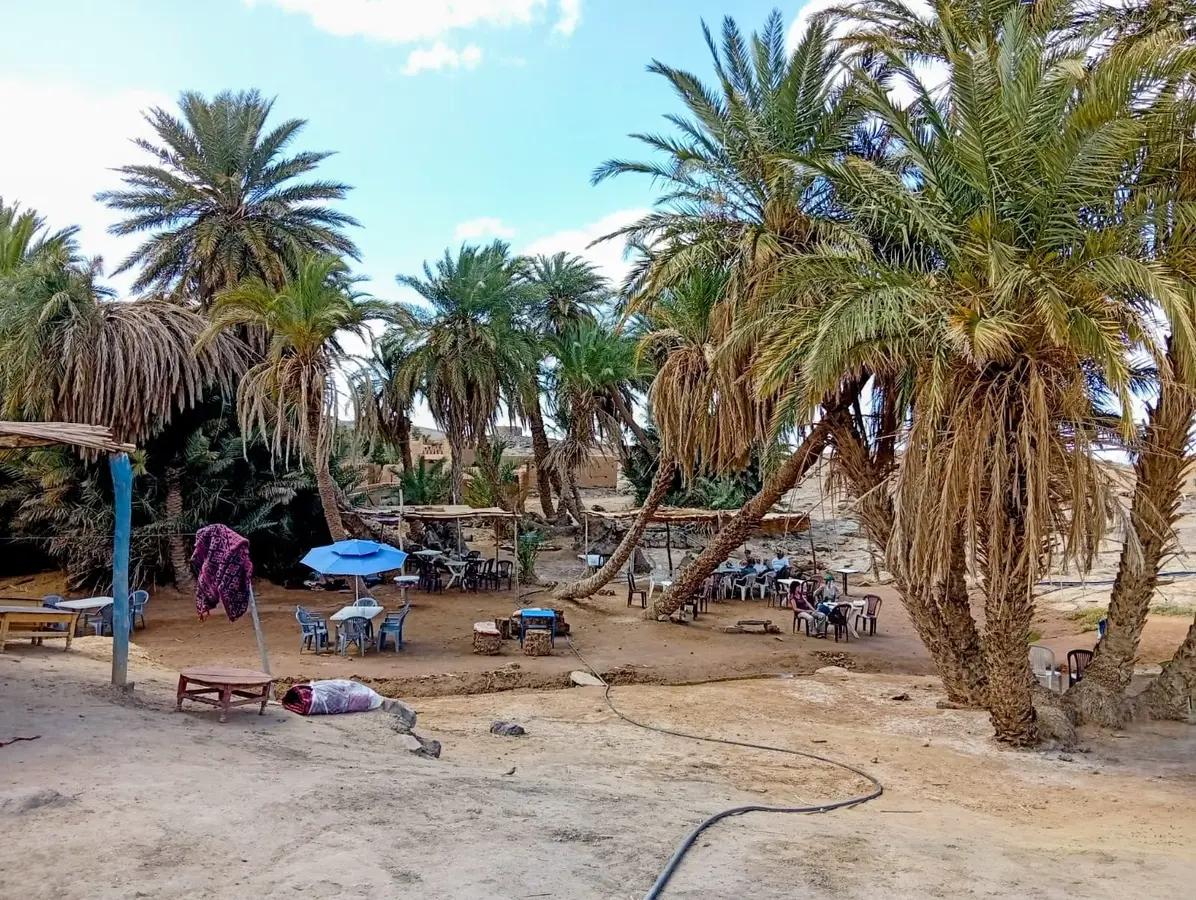
A line of palms tells you that water has been reached, lifted, divided and protected. A well is evidence of repeated knowledge, not simply a hole in the ground. A route may have no signpost and still be remembered by families, guides, herders and drivers. An abandoned wall may be part of a ruined ksar, while a nearby house belongs to a family living an entirely modern life. Animal tracks cross a surface that seems blank. A camp becomes a place of work, conversation and shelter. The quiet is not the same thing as absence.
M’Hamid El Ghizlane is one of the best places to understand this difference. At the southern end of the Draa Valley’s oasis sequence, it stands where cultivated land, settlement and desert travel meet. M’Hamid is often described as a gateway to the Sahara. The phrase is useful, but only if the visitor understands what lies behind the gate: not an empty wilderness, but a lived landscape whose geography is made from water, movement, labour and memory.
The desert looks empty from a distance
The word “empty” usually describes what cannot be seen from far away. It says more about the observer’s scale than about the land itself.
Cities announce their human presence through roads, roofs, signs and noise. Deserts record it differently. Human activity may be concentrated around a spring, a well, a palm grove or a route between two reliable points. It may be seasonal rather than permanent. A place can be used by people without being built over, and known without being marked on a tourist map.
This does not mean that every part of the Sahara has been equally inhabited, nor that the desert has never contained genuinely remote areas. It means that “uninhabited” and “unseen” are not synonyms. The surrounding Moroccan Sahara includes spaces that have been travelled, grazed, crossed, remembered and governed without resembling a city.
The Draa Valley makes this visible because its green zones are concentrated and fragile. Water supports palms and horticulture, while earth-built settlements gather around the agricultural system. Beyond the cultivated belt, the relationship with the desert becomes more mobile and more dependent on seasonal conditions. The contrast between green and sand can tempt a visitor to imagine two separate worlds. Historically, they were connected. Oasis farmers, pastoralists, traders and travellers depended on one another in different ways.
Archaeology has also shown that the Draa is not merely a scenic corridor between the Atlas and the dunes. The Middle Draa Project surveyed roughly 200 kilometres of the valley at the northern edge of the Moroccan Sahara. Its work established a new archaeological baseline and identified evidence relevant to the early development of settlement and oasis agriculture during the Protohistoric or Iron Age period. That evidence does not produce a single origin story for the valley. It shows a long relationship between people and a demanding environment.
M’Hamid: where the oasis meets the desert
M’Hamid sits at the southern end of the great Draa oasis sequence. Cultural-landscape documentation describes the valley as a chain of oasis zones, with date palms and smaller cultivation sustained by irrigation. M’Hamid is the last of these major oasis stretches before routes continue toward the more open desert and Erg Chegaga.
The word oasis can sound like a description of scenery. It is better understood as a system.
Water makes cultivation possible. Cultivation produces food, shade and material for exchange. Palms create a protective upper layer beneath which other plants can grow. Fields require labour, timing and maintenance. Settlements develop around these resources. Animals feed on cultivated residues or nearby pasture. People move between the oasis and the wider desert for work, grazing, transport and trade. The system is not self-sustaining by magic; it survives through knowledge and continual effort.
The Draa’s water is not evenly available throughout the valley. The lower river may run dry for much of the year, and oasis agriculture depends on irrigation, local water management and changing environmental conditions. A palm grove therefore tells a story of organisation. It marks not only where water exists, but where people have learned how to share, direct and protect it.
M’Hamid’s settlements and surrounding villages include earthen architecture, ksour and kasbahs. The terms describe different forms of built space, and they should not be used as interchangeable decoration. A ksar is generally a fortified settlement or collective village; a kasbah can refer to a fortified house or larger residence, though local usage and architectural forms vary. Around M’Hamid, places such as Ouled Driss and Bounou are connected to the palm-grove landscape and retain notable earthen structures.
These buildings are not only picturesque remains. They record how people adapted architecture to climate, resources and social life. Their walls carry the marks of construction, maintenance, abandonment and repair. Some are fragile, and their survival depends on decisions made by residents, owners, authorities and cultural organisations. A ruin is not a silent object if people still argue about what it means, what should be protected and who has the right to use it.
A landscape full of routes
A desert route does not need a painted sign to be real.
It may be a remembered line between wells, a seasonal passage for animals, a track altered by wind, or a journey whose importance lies in the relationships it connects. Routes are made by repetition. They depend on knowledge of distance, water, terrain, weather and the limits of animals and vehicles. They also depend on people who know when not to travel.
The Draa Valley formed part of wider networks linking oasis settlements with the Sahara and, at different periods, with markets and routes farther south. The safest historical description is not that M’Hamid was a single, dominant caravan capital. It is that the oasis-and-desert system helped support movement. Settled communities could provide food, water, animals, labour and shelter. Mobile communities carried knowledge of dryland routes and pasture. Traders, religious travellers, farmers and herders moved through overlapping geographies.
Cultural documentation places Agdz, farther north in the Draa Valley, on an old route linking Marrakech and Timbuktu. This helps establish the valley’s wider historical connectivity, but it should not be turned into a claim that every commercial route passed through M’Hamid or that modern excursions reproduce medieval caravan journeys. Routes changed with politics, security, markets, borders and water.
Trade in the western Sahara involved different goods and different scales of exchange over time. Yet the available sources consulted for this article do not justify attaching a fixed list of cargoes or a precise caravan timetable specifically to M’Hamid. That restraint matters. A place does not become more interesting when history is inflated. M’Hamid is already significant as a threshold where the final oasis, desert travel, agriculture and mobile pastoral worlds meet.
The invisible geography continues today. A driver knows where a track becomes difficult. A guide knows which landscape feature is useful and which is misleading. A farmer knows the condition of a field. An animal recognises a route through repeated movement. A family knows which places are private, shared, seasonal or unsafe. None of this is visible in a photograph taken from above.
The knowledge that makes a desert livable
Survival in dry country is not one heroic skill. It is an accumulation of ordinary, specialised decisions.
Water must be located, lifted, stored and used carefully. Pasture must be judged against the needs of the herd and the likelihood of its renewal. Weather must be watched because rain can change both opportunity and danger. Routes must be adjusted when a track is buried, a well fails, or a vehicle cannot pass. Animals require care, and the distance between one reliable resource and the next is never an abstract measurement.
Research on Moroccan pastoralism distinguishes among nomadic, semi-nomadic and transhumant forms of mobility. The terms describe different patterns rather than a single lifestyle. In the pre-Saharan and Saharan south, mobile pastoralism has persisted in varied forms, while schooling, healthcare, settlement, borders, drought, land change and employment have altered older movements. A family may live in a house and still keep animals, travel seasonally or retain detailed knowledge of a wider territory.
This knowledge also belongs to oasis life. Palm cultivation is not a passive response to nature. It requires labour and coordination. Fields, channels, trees and harvests form part of a managed environment. Food connects the oasis to the market and to the camp. Animals connect cultivated land to pasture. Hospitality can be generous, but it also exists within economies of work and exchange. Crafts carry skill and income. Music and oral storytelling carry memory, although neither should be treated as a single tradition shared identically by everyone in the Sahara.
The phrase “traditional knowledge” can become vague if it is used to praise people without learning what they actually know. In M’Hamid, a better approach is specific. Ask how a guide reads a route. Ask what a palm grove requires. Ask how a family describes seasonal movement. Ask which local history is remembered and which part remains uncertain. Knowledge becomes visible through questions that respect the person answering them.
The same principle applies to cultural labels. Amazigh identity is important in the history of many southern Moroccan communities, including groups associated in regional research with the Aït Atta and Aït Khabbash. But not every person in M’Hamid belongs to one tribe, one language community or one social category. Arab, Amazigh, Sahraoui, oasis, mobile and settled identities should not be arranged into a simplified “Sahara culture.” They overlap in some histories and differ in others.
The people who are still here
The Sahara is not populated only by ancestors.
M’Hamid today includes residents, farmers, families, drivers, guides, craftspeople, camp workers, shopkeepers, teachers, young people seeking employment and people whose lives connect the town with other Moroccan cities or countries. Some work in tourism. Some maintain agricultural ties. Some have family histories of pastoral mobility. Some have no reason to describe themselves through the categories a visitor expects.
The region’s present is shaped by environmental pressures as well as opportunity. A study of the M’Hamid oasis using satellite imagery and field and administrative data examined vegetation change from 1984 to 2016. It reported a 22 per cent loss of oasis area and a 21 per cent decline in inhabitants over the periods studied, and associated degradation with irregular rainfall, drought, dam effects, tourism and outmigration. Those figures belong to that study and period; they should not be treated as a current census or a complete explanation of the oasis.
The study matters because it makes the landscape’s vulnerability visible. When fields are abandoned, sand can move into cultivated areas. When water becomes less reliable, the relationship between palm, crop, animal and household changes. When young people leave for work, knowledge and labour are redistributed. These are not picturesque signs of a vanishing culture. They are pressures affecting people who are making difficult decisions.
Tourism is part of this present. It can create work for local guides, transport providers, camps, cooks, artisans and other businesses. It can also simplify a community into an image of “authenticity,” rewarding the performance of a past that no resident is obliged to live. A visitor who asks before photographing, listens to explanations, respects private spaces and supports locally owned services participates differently from one who treats people as scenery.
A desert camp is not outside modern life. It may use solar energy, vehicles, mobile phones, online reservations, GPS and bank transfers. A guide can understand a route through family experience while checking a weather forecast on a smartphone. A young person can value local history and still want education, professional work or a life beyond tourism. Continuity is not the refusal of change.
What modernity changed — and what it did not
Roads altered the rhythm of the region. They made towns and services more accessible and allowed goods, vehicles and people to move in ways that were impossible or slower before. Schools encouraged some families to settle near education. Medical care created reasons to remain connected to towns. Wage employment changed the economics of herding and agriculture. Phones reduced the isolation of a journey. GPS reduced some risks and altered the meaning of route knowledge.
These changes brought benefits as well as losses. It would be careless to describe modern services as enemies of culture. A family may choose settlement because it wants its children to attend school. A guide may use technology because it makes work safer. A farmer may install a pump or solar panel because water and energy systems have changed. People are not obligated to preserve hardship in order to prove cultural continuity.
At the same time, modernisation can narrow older possibilities. Borders can close routes. Land may be privatised or used differently. Drought can reduce pasture and water. Tourism can bring income while making local livelihoods dependent on external demand. Environmental and economic pressures may push people to migrate. The result is not a simple division between old and new, but a changing set of choices.
Research on Aït Khabbash communities in the wider Draa-Tafilalet region describes the combined effects of restricted mobility, drought, settlement, migration and community-led tourism. This evidence is regionally relevant, not a description of every M’Hamid family. Its wider lesson is that adaptation is often built from below. People combine local knowledge, new technology, family networks and whatever work is available.
A GPS can show a driver where a vehicle is. It cannot explain who has used a well, how a track changes after weather, or whether a place is private. A map can reduce distance to a line. A local guide can restore the human scale of the journey. Neither tool has to replace the other.
Why “empty” is the wrong word
The desert is not full in the same way a city is full. It does not offer a continuous wall of buildings, a constant flow of traffic or a visible crowd. But human presence has never required a city’s density.
At M’Hamid, presence is written in palms and irrigation, in houses built from earth, in the memory of routes, in the work of maintaining a field, in the tracks of animals, in the decisions made around water and in the conversations that connect a visitor to a place. It is held by families who stay, families who move, families who return and families whose work now links the oasis to distant markets.
The desert can appear empty because its signs are not designed for an outsider’s quick reading. A ruined ksar does not announce every household that once occupied it. A well does not list the people who depended on it. A track does not display the generations that travelled it. A campfire does not reveal every relationship formed around it. Absence is sometimes real, but invisibility is not the same thing.
To cross the desert respectfully is therefore to cross a human landscape as well as a physical one. Listen to local guides. Ask before photographing people. Respect homes, camps and private places. Support local businesses where possible. Do not expect a person to perform an imagined past for your camera.
M’Hamid does not need to be made dramatic by calling it the last edge of civilisation or the beginning of nowhere. It is more truthful, and more compelling, to see it as a place where a civilisation of water, work and movement meets a modern world that is still changing it.
From a distance, the Sahara may look like nothing. Up close, it becomes legible: a palm, a wall, a track, a well, a voice, a family, a choice. The desert was never empty. We were simply looking from too far away.
🐪 Discover the living desert around M’Hamid with our travel guide. travel-guide.html → · about.html →