Before M’Hamid was a destination, it was a calculation.
Where can water be found? How can it be held, guided and shared? Which plants can survive beneath the palms? How close should homes stand to fields, shade and one another? When should a family plant, harvest, repair, move animals or leave a plot fallow?
The visible town is only one part of the answer. M’Hamid became possible because an oasis made life possible first.
At the southern end of the Draa Valley, the M’Hamid oasis marks the last palm-grove zone in the valley’s sequence before the landscape opens toward the desert. It is often described as a gateway, an endpoint or the place where the paved road gives way to sand. Those descriptions are useful for a visitor, but incomplete for understanding the place. M’Hamid is not simply where the road ends. It is where water, agriculture, architecture, mobility and memory meet.
The oasis is not a natural island of green appearing by accident in a sea of sand. It is a living system shaped by river flows, groundwater, irrigation, palms, cultivation, settlement and labour. Its existence has always depended on conditions that are limited and changeable. The same water that made a village possible also set limits on its size. The same palm grove that offered shade could be damaged by drought, salinity, sand encroachment or abandonment.
To look at M’Hamid properly is therefore to look beneath the palms.
The last palm grove of the Draa
The Draa Valley is a long sequence of oasis zones extending from the Anti-Atlas toward the edge of the Sahara. Archaeological research identifies the Middle Draa as a broad oasis belt divided into several palm-grove regions, with Mhamid at its southern extremity.
The word “last” can make M’Hamid sound like a dramatic final outpost. Geographically, it means something more precise: M’Hamid is the last major palm-grove zone in the Draa sequence before the cultivated valley gives way to more open desert landscapes. The oasis does not form a wall between two worlds. It is a transition.
The Draa’s water has never been evenly abundant. The valley lies in an arid to hyper-arid region where rainfall decreases toward the south and potential evaporation is high. The river’s flow depends on conditions upstream, and water reaching the lower oases can vary greatly. In earlier periods, floods, river channels, groundwater and local irrigation works all mattered. In the modern period, reservoirs and managed releases have added another layer of water control.
The oasis is consequently both ecological and social. Water is a physical resource, but its movement also requires decisions, maintenance and cooperation. A channel must be cleared. A distribution point must be managed. A field must be prepared. A palm must be tended. A damaged wall or irrigation structure must be repaired. The green appearance of an oasis conceals a large amount of work.
What a palm grove does
A date palm is more than a crop planted in dry ground.
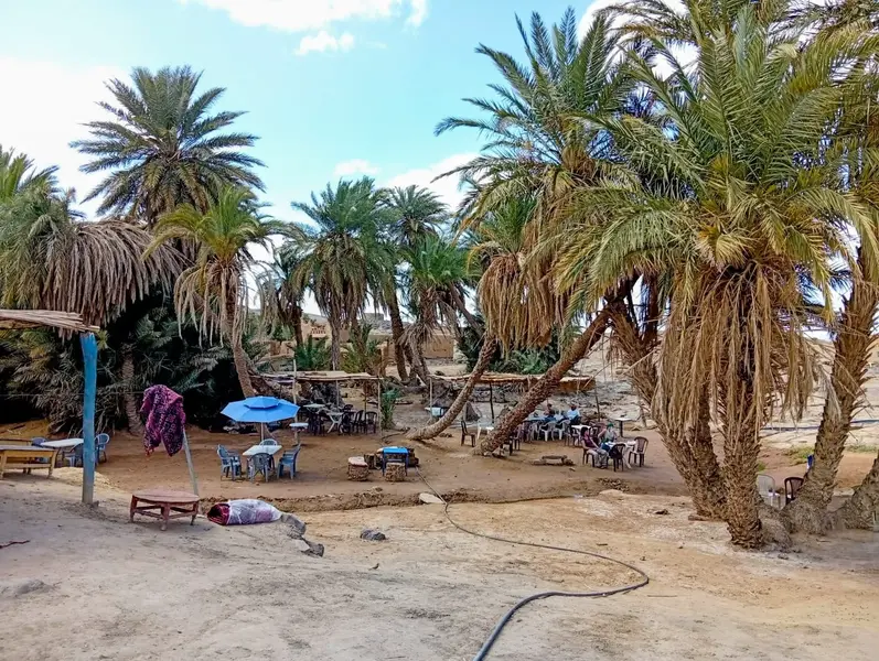
Its height creates shade. Its canopy alters the conditions below. Under the palms, farmers can cultivate plants that would face greater heat and evaporation in the open. The Food and Agriculture Organization describes the Moroccan date palm as the foundation of an economic, social and environmental ecosystem and notes that its shade creates a microclimate favourable to other crops.
This does not mean every oasis has an identical three-storey agricultural design or that every plant grows everywhere. Local soils, water availability, cultivation choices and household resources differ. The important principle is that the palm grove makes layered agriculture possible. It reduces exposure and creates a productive space in an otherwise difficult climate.
The lower layer may include vegetables, fodder or other crops where water and soil allow. Animals can also be part of the wider oasis economy, providing labour, manure, food or income. Houses, storage areas, gardens and paths occupy the same general environment. The oasis is not a single field. It is a relationship among several uses of land.
For a traveler, the first impression may be visual: green fronds against dry earth. For a resident, the palm grove is also time. It requires seasonal tasks, inherited techniques and decisions about water. A palm can outlast a household’s immediate plans, but it still depends on present care.
The grove also protects more than crops. Shade, walls, vegetation and compact settlement can create small differences in temperature, wind and comfort. This is not a promise of a uniform oasis climate. It is a reminder that oasis architecture and agriculture respond to heat through design rather than treating the environment as empty space.
Water is not scenery
A visitor may see an irrigation channel and read it as an attractive detail. For the oasis, it is a working boundary between possibility and loss.
The Middle Draa’s irrigation systems have been studied through archaeology, field survey and satellite imagery. Researchers have identified canals, field systems, distribution channels and abandoned gardens, including in areas east of Mhamid where dunes have partly overwhelmed former cultivation.
These traces show that water management is not a recent addition to an otherwise natural landscape. It has a long history, although its exact origins and stages differ from one part of the valley to another. The archaeological record is incomplete. Modern cultivation can cover earlier systems, while abandoned areas can preserve traces that remain difficult to date.
A recent archaeological study of the Wadi Draa found that oasis agriculture and settlement existed before the eighth century and expanded significantly from the ninth century onward. It identifies a substantial boom in settlement and irrigated agriculture between the eleventh and thirteenth centuries, followed by the contraction and abandonment of much of the studied oasis area by the sixteenth century.
This chronology comes principally from the Kasr Bounou Plain and wider Wadi Draa research. It should not be turned into a precise biography of every M’Hamid village. Its importance is broader: it demonstrates that oasis landscapes are historical systems. They expand, reorganise, decline and sometimes return. The desert edge is not outside history. It is shaped by decisions made across centuries.
Water distribution also creates social relationships. Farmers depend on more than rainfall. They depend on access, timing, maintenance and agreements. It would be misleading to claim one uniform water law across all of M’Hamid without local documentation. The safer conclusion is that agriculture has always required coordinated knowledge of water and land.
The settlement beneath the sand
M’Hamid is often encountered through its modern town and tourism infrastructure. Yet the oasis includes a wider settlement landscape of villages and ksour.
A 2017 heritage study describes thirteen villages, or ksour, in the M’Hamid oasis and examines their architectural, urban and social similarities with other pre-Saharan settlements. A ksar is not merely an old building. It can include homes, passageways, communal spaces, storage, defensive features and relationships to fields and water. The exact form varies, and not every historic structure should be assigned the same function.
Earthen architecture is particularly suited to a place where local materials, shade and thermal moderation matter. But earthen buildings require maintenance. Roofs, walls and surfaces are vulnerable to rain, wind, erosion, abandonment and changes in household life. When people leave, a building may lose not only its residents but also the routine labour that keeps it usable.
The archaeological survey of the Draa has found fortified villages, mudbrick settlements, abandoned gardens and structures partly covered by drifting dunes. Some sites are medieval; others belong to later periods; many remain incompletely dated. The landscape should therefore be approached with respect for uncertainty. A ruined wall does not automatically reveal its age, its owner or its role in caravan history.
What it does reveal is that M’Hamid was never just a camp beside empty dunes. People built durable relationships between homes, fields, water and movement. The oasis supported settlement because settlement, in turn, maintained the oasis.
A place made by work
The oasis can appear effortless from a distance. Palms hide the channels. Greenery softens the boundaries between field and path. Walls merge with the colour of the ground. The result looks like a natural answer to the desert.
It is not effortless.
Water must be lifted, directed, released or conserved. Fields must be prepared. Palm fronds and dead material must be managed. Crops must be planted and harvested. Buildings must be repaired. Animals must be cared for. Knowledge must move between generations. The word “tradition” can make these activities sound static, but an oasis survives through adjustment.
That adjustment has never been purely agricultural. Families make choices about education, work, migration, housing and tourism. A heritage workshop can be part of the contemporary economy. A guide can work with visitors while remaining connected to an oasis community. A restored earthen wall can become both a cultural resource and a source of income. These developments are not proof that the oasis has been preserved in an unchanged state. They show that people continue to negotiate its future.
The heritage study of M’Hamid documents restoration workshops organised since 2012, involving local craftsmen and international participants. Such work cannot replace the living functions of an oasis, but it can help preserve buildings, skills and public attention. Conservation is strongest when it supports residents rather than turning their homes into scenery.
The oasis and movement
M’Hamid’s oasis also made movement possible.
Travelers, pastoralists, farmers, guides and traders needed places where people and animals could rest, find supplies, obtain information and continue. The Draa’s oasis chain formed a connected landscape rather than a series of isolated green spots. M’Hamid’s position at the southern end gave it a particular relationship with routes leading into more open desert, but this does not mean that every historical traveler passed through the town or that every local person was a caravan merchant.
The oasis supported movement because it supported life. Dates, crops, water, shelter, animals, labour and local knowledge all mattered. A settlement could be a place of exchange without being defined only by long-distance commerce. A family moving with animals, a farmer visiting another village, a pilgrim, a guide and a merchant could all use the same geography for different reasons.
This is why the history of M’Hamid should not be reduced to a romantic image of caravans arriving at the last palms. The caravan story is part of a larger story about settlement and resource management. People crossed the desert because certain places made crossing possible. Those places were maintained by communities whose lives cannot be treated as background to trade.
What the water crisis reveals
The present vulnerability of the oasis makes its earlier achievement clearer.
A water-supply study of the Middle Draa describes a region facing increasing scarcity under climate and socioeconomic change. Its modelling indicates declining available water resources under the study’s climate scenario, rising demand across socioeconomic scenarios and increasing reliance on groundwater for irrigation during drought years.
The study also finds important differences among oases. Groundwater recharge is stronger in northern oases than in southern oases under the model’s assumptions, and M’Hamid is one of the downstream oasis systems represented in the analysis. The study is a model, not a prediction of one inevitable future. Its value is in showing how climate, land use, irrigation and demand interact.
A separate study focused on M’Hamid used Landsat imagery, GIS analysis, administrative data and fieldwork to examine vegetation change between 1984 and 2016. It reported a 22 per cent loss of oasis area and a 21 per cent reduction in inhabitants across the study periods, associating the changes with drought, rainfall irregularity, dam construction, tourism and outmigration. These are study-specific results and should not be presented as a current census or as proof of one single cause.
The pressure is not only a story of water disappearing. It is also a story of water becoming harder to distribute, fields becoming less reliable, households changing their livelihoods and younger people weighing opportunities elsewhere. When agriculture weakens, the physical oasis and the social system that maintained it can weaken together.
The date palm remains economically and culturally important in Morocco, but national production figures cannot be used as a direct measure of M’Hamid’s condition. A thriving national sector can coexist with local water stress. Scale matters.
Seeing M’Hamid differently
A visitor may arrive because the asphalt road ends nearby and the desert begins. But the journey does not enter an empty landscape at that point.
It enters a place made possible by water. The palms are evidence of irrigation, not simply decoration. The fields are evidence of labour. The ksour are evidence of settlement, repair and social organisation. The routes beyond the oasis are connected to a place where people could live, prepare, exchange and recover. The desert around M’Hamid is not separate from the oasis. Each gives meaning to the other.
This perspective also changes the way a traveler should move through the area. Walk carefully near cultivated plots. Do not treat irrigation channels as ornaments or private spaces as photo opportunities. Ask before photographing residents, workers, homes or ceremonies. Use local guides and services where possible. Listen when someone explains which land is active, which wall is fragile or which route should not be taken.
An oasis is not just a green place in a dry country. It is a negotiated relationship between water, plants, animals, buildings and people. Its beauty is real, but beauty is not the whole explanation.
The oasis made the town possible
M’Hamid can be imagined as a threshold: behind it, the Draa’s palm groves and settlements; beyond it, the routes toward the wider desert. But a threshold is useful only because something has been built around it.
The oasis made settlement possible. Settlement made agriculture and exchange possible. Agriculture supported people and animals. People maintained water systems, buildings and routes. Those relationships changed through time, and they are under pressure now.
To stand among M’Hamid’s palms is therefore to see more than an oasis at the end of a valley. It is to see a long argument with aridity, conducted through channels, shade, mudbrick, cultivation, movement and care.
The desert did not make M’Hamid impossible. It defined the terms on which M’Hamid could exist.
And the oasis answered, for as long as water, knowledge and work could hold the answer together.
🐪 Walk the oasis of M’Hamid with our travel guide. travel-guide.html → · long-treks.html →